Whitehaven
Mariners' Museum, Uncurated Search Results
Type: Schooner Barge
Year: 1919
Builder: Whitehaven Shipbuilding Co.
Location: Whitehaven
These records are found in the online catalog of The Mariners’ Museum and Park in Newport News, Virginia. Uncurated search results are presented to give researchers and interested readers an idea of whether the museum’s archives contain information about this vessel and whether it may be worthwhile to visit the museum’s catalog search page for further investigation. Uncurated results may be inaccurate or incomplete.
Search mode: Exact Name. Search phrase(s): "Whitehaven". Results returned: 21. Results displayed in this table: 21.
Use these buttons to send uncurated search results to your own app or text document for further research. First, check the box for any row, or click "Select All" then uncheck any rows. Then click "Show Selections". You can then copy your selections from the text box and past them into your app.
| Fetch? | Row ID | Media | Date | Vessel | Place | Related Places | Inscription/Marks | Subject | Notes | Archive Number |
|---|---|---|---|---|---|---|---|---|---|---|
| 1 | No image URL. | Harbors–Great Britain. | Whitehaven existed prior to 1150. The chief export was coal from nearby fields and shipbuilding began around 1690. | LB67816 | ||||||
| 2 | No image URL. | Whitehaven (England)–History–Miscellanea; Virginia–History–Miscellanea–Colonial period, ca. 1600-1775; Maryland–History–Miscellanea–Colonial period, ca. 1600-1775; Whitehaven, Cumbria–Relations (general) with Virginia; Virginia–Relations (general) with Whitehaven, Cumbria | Includes index. | LB1978 | ||||||
| 3 | 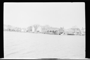 | 4/1952 | Wicomico County (Md.).; Wicomico River (Wicomico County and Somerset County, Md.). | Envelope: "Whitehaven. April 1952" | Dwellings–Maryland–Wicomico County.; Harbors–Maryland–Wicomico County. | Shows a view looking across the water towards some homes and a covered wharf. There is no caption for this negative. | MS0063/01-697#0697-A | |||
| 4 | 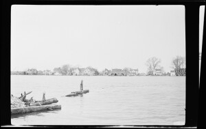 | 4/1952 | Wicomico County (Md.).; Wicomico River (Wicomico County and Somerset County, Md.). | Envelope: "Whitehaven. April 1952" | Dwellings–Maryland–Wicomico County.; Harbors–Maryland–Wicomico County. | Shows a view looking across the water towards some homes and a covered wharf. There is no caption for this negative. | MS0063/01-697#0697-D | |||
| 5 | No image URL. | Whitehaven, Maryland | P0001.008/01-702 | |||||||
| 6 | 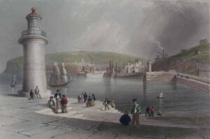 | SHORT DESCRIPTION: The image depicts a close-up view of Whitehaven Harbour. The piers have several groups of people sitting and standing. There are two lighthouses in the scene, as well as several ships in the harbor and many more ships docked in the inner harbor. In the background of the image is the town of Whitehaven. NOTES: The image is from the end of the West Pier with the West Pier Lighthouse as the featured structure. It was built in 1832 and again in 1841. The second lighthouse is a little farther in the distance on the right, the Old New Quay Lighthouse, built in 1742. And just beyond that, almost nestled amongst the masts of the ships in the inner harbor, is the Whitehaven watchtower built around 1730 on the Old Quay. The towers that are visible on the hills with smoke coming from them are the ventilation stacks for the coal mines. NOTES: The image is from after page 168 of the appendix of volume 1 of “The Ports, Harbours, Watering-Places, and Coast Scenery of Great Britain," published by George Virtue in 1842. (TMMP Library DA625 .F49 Rare) The book was first published in 1838 by Charles Tilt with descriptions by William Andrew Chatto. It was then published several times in 1839 and 1842 by George Virtue, and later after 1855 by Virtue & Co. under George’s son, James S. Virtue. The name also changed slightly, but kept the "Ports, Harbours, and Watering Places" part of the title. The books that the Virtues published kept Chatto’s descriptions for the first volume, but they expanded the book to two volumes. William Beattie wrote the text for the new second volume and an appendix added to the end of the volume 1. NOTES: From the end of the 1842 edition of Volume 2: “In taking leave of these two Volumes, illustrating the Ports, Harbours, Watering-places, and Coast Scenery of Great Britain, a few words of explanation appear necessary. The work was originally commenced by Messrs. Finden [William and Edward], and for some time carried on with all the taste and spirit characteristic of these distinguished Artists. But the remuneration accruing from the sale being found inadequate to defray the expenses incurred in its production, it was offered to the present Publisher, who readily saw the improvements of which it was susceptible and became the purchaser. Arrangements were then made for its continuation. Mr. BARTLETT, whose illustrations are so familiarly and favourably known to the Public, set out on a tour of observation along the northern coasts of England and Scotland; and, after visiting every locality indicated, returned with a portfolio of drawings taken on the spot. These were immediately placed in the hands of eminent engravers; a re-issue and continuation of the work were announced; and it is gratifying to state, that the reception which it has since met with from the Public has been most liberal. With regard to the letterpress descriptions, I beg it to be expressly understood that the labours of my pen have been confined to the Second Volume and the Appendix of Vol. 1. The First Volume was written under the signature W.A.C. - prior to my connexion with the work; and, in justice to that author, I feel it at once a duty and a pleasure to conclude the work with this statement. William Beattie, M.D.” January 1842 J. Rickerby, printer, Sherbourn Lane An excerpt from The Ports, Harbours, Watering-Places, and Picturesque Scenery of Great Britain about the print. “Whitehaven forms one of a chain of ports on the north-western coast of England, which owe their commercial importance to the demand for coals. This branch of trade has long been famous a nursery of hardy and intelligent seamen, and the naval service of the country has, in times of war, been chiefly indebted to the numerous body of men who have, either voluntarily or by compulsion, exchanged their services from the humble collier to a more distinguished, though less lucrative, position on the deck of a line-of-battle ship. Years have not passed since there has been any occasion to disturb the arrangements of our commercial marine for this purpose; and it is to be fervently hoped that the advancing civilization of the age will preclude the re-enactment of such scenes of misery and crime as a must ever accompany the system of impressments and forced service.” | CL16289 | |||||||
| 7 | 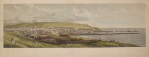 | WHITEHAVEN FROM BRANSLAY HILL - [ENGLAND] | CL8098 | |||||||
| 8 | 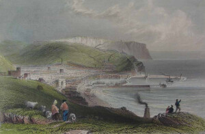 | SHORT DESCRIPTION: The image depicts the town of Whitehaven along the northwestern coast of England. In the foreground of the image are two shepherds (a man and a woman) with sheep, and three other people sitting on the rocks looking down upon the town of Whitehaven. In the background is the prosperous town of Whitehaven and its large port with one ship docked and another leaving the port. There are ships on the beach, ships in the harbor, and church towers and an arch in town. At the end of the piers there are lighthouses. The background includes hills and the cliffs of St. Bees-Head Nature Reserve. NOTES: The arch in the image is probably the Bransty Arch, built before 1784 to allow merchants to transfer coal to and from waiting ships. It was torn down in 1927. The arch itself was shorter than what appears in this print. The church on the hill at the left is St. James’ Church, built between 1752-53. The towers that are visible on the hills with smoke coming from them are the ventilation stacks for the coal mines. NOTES: The straight pier that is closest to the foreground is the North Pier, with the construction at the end for what would become the North Pier Lighthouse, built in 1841. Halfway up the North Pier there is a wall that separates the inner harbor (where there are many ships’ masts visible on the left of it) and stretches toward the background. This wall is part of the Old Quay and there is a tower that is often mistaken for a lighthouse. The Whitehaven watchtower was built possibly as early as 1730 and has a sundial on the side. The second pier which curves at the right side and has two towers is the West Pier. The lighthouse at the end of the West Pier is the West Pier Lighthouse, built in 1832 and again in 1841. The tower that is halfway up the west pier is the Old New Quay Lighthouse, which was built in 1742. NOTES: The image is most likely from page 166 of the appendix of volume 1 of “The Ports, Harbours, Watering-Places, and Coast Scenery of Great Britain," published by George Virtue in 1842. (TMMP Library DA625 .F49 Rare) The book was first published in 1838 by Charles Tilt with descriptions by William Andrew Chatto. It was then published several times in 1839 and 1842 by George Virtue, and later after 1855 by Virtue & Co. under George’s son, James S. Virtue. The name also changed slightly, but kept the "Ports, Harbours, and Watering Places" part of the title. The books that the Virtues published kept Chatto’s descriptions for the first volume, but they expanded the book to two volumes. William Beattie wrote the text for the new second volume and an appendix added to the end of the volume 1. NOTES: From the end of the 1842 edition of Volume 2: “In taking leave of these two Volumes, illustrating the Ports, Harbours, Watering-places, and Coast Scenery of Great Britain, a few words of explanation appear necessary. The work was originally commenced by Messrs. Finden [William and Edward], and for some time carried on with all the taste and spirit characteristic of these distinguished Artists. But the remuneration accruing from the sale being found inadequate to defray the expenses incurred in its production, it was offered to the present Publisher, who readily saw the improvements of which it was susceptible and became the purchaser. Arrangements were then made for its continuation. Mr. BARTLETT, whose illustrations are so familiarly and favourably known to the Public, set out on a tour of observation along the northern coasts of England and Scotland; and, after visiting every locality indicated, returned with a portfolio of drawings taken on the spot. These were immediately placed in the hands of eminent engravers; a re-issue and continuation of the work were announced; and it is gratifying to state, that the reception which it has since met with from the Public has been most liberal. With regard to the letterpress descriptions, I beg it to be expressly understood that the labours of my pen have been confined to the Second Volume and the Appendix of Vol. 1. The First Volume was written under the signature W.A.C. - prior to my connexion with the work; and, in justice to that author, I feel it at once a duty and a pleasure to conclude the work with this statement. William Beattie, M.D.” January 1842 J. Rickerby, printer, Sherbourn Lane An excerpt from The Ports, Harbours, Watering-Places, and Picturesque Scenery of Great Britain about the print. “The town of Whitehaven may be considered as a national monument to the creative influence of trade. Favoured by the geological character of its soil, and fostered by native industry, it has risen in the comparatively brief interval of a hundred and eighty years, to a position of eminence among the minor ports and harbours of Great Britain. What in the middle of the seventeenth century consisted, according to written testimony, of only six fishermen’s huts and one small bark, is now a flourishing town, enlivened by trade and commerce with a commodious harbour, extensive shipping and enterprising merchants. The bay on which the town of Whitehaven is erected is so deeply seated, that the adjacent shore, rising like the grade of magnificent amphitheatre, appears to enclose it on every side. In approaching it from the north, the stranger is uniformly stuck with its sheltered position and from the heights looks down upon it as a map spread at his feet. From the south the view is particularly beautiful. The town is well built, the streets wide and enlivened with well-furnished shops, and inhabited by a cheerful and thriving population. Like Longtown, on the Border, Whitehaven is built after a correct plan; the streets cross each other at right angles, presenting much architectural regularity, and combining with the air of internal comfort, the outward signs of taste and elegance. The public improvements continue to advance in proportion to the extent of commercial intercourse, and to this, apparently, every succeeding year throws open some new channel. The introduction of steam-navigation between all the adjacent as well as opposite coasts, has powerfully contributed to stimulate the native industry of the place by increasing the demand for coal- its staple produce- to which we shall more particularly advert in our notice of the harbour. The situation of Whitehaven in a narrow valley, extending to the village of St. Bees- a distance of several miles- unites with the appearance of seclusion much of that picturesque beauty for which the inland districts of the county are so justly celebrated. St. Bees-head is a bold and striking feature, and contrasts admirably with the softer scenes from which it projects, as the most imposing landmark on this part of the channel. The population of Whitehaven has greatly increased within the last ten years. The neighbouring villages, farms, and pastures, all indicate a progressive advancement in the several branches of domestic industry. The land is highly cultivated, and in many instances fertile and productive; white the orchards and gardens, by nature and abundance of their produce, bear friendly testimony to the mildness of the climate. […] The inhabitants of Whitehaven are noted for their public spirit, honourable conduct in trade, and for that indefatigable attention to business which has so happily distinguished them through a long series of years. It has several schools, two weekly papers, and the study of literature and science is much cultivated and encouraged by the families of affluence and respectability who reside in the town and vicinity. Social and hospitable intercourse, with balls, assemblies and public fetes, render the stranger’s residence at Whitehaven extremely agreeable. It offers, in general, all the luxuries of a country town, with few or none of its disadvantages; and presents at all times the means of prompt intercourse with the great commercial emporium of Liverpool, the coasts of Scotland, Ireland, Wales and the Isle of Man. Independently of its immediate vicinity to the Lakes, it would be difficult to point out any situation in the northern counties which enjoys so many attractions in regard to situation, scenery, and society, as the picturesque and prosperous town of Whitehaven.” | CL16288 | |||||||
| 9 | No image URL. | Lifeboats. | Beneficial services of lifeboats at Fraserburgh and Whitehaven, Oct. 11, 1808. Used for the first time. | LB71913 | ||||||
| 10 | 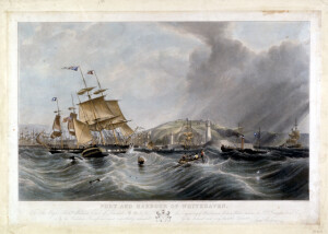 | THE PORT AND HARBOR OF WHITEHAVEN | CL17165 | |||||||
| 11 | No image URL. | Brocklebank Line–History.; Jefferson Line–History; Thomas & John Brocklebank (Firm).; Jefferson (Robt. & Henry) Ltd | Shipping–History. Great Britain | Includes indexes. | LB17329 | |||||
| 12 | 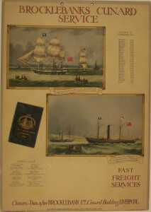 | SHORT DECRIPTION: Placard with small attached folder for Lloyd's Register of Shipping and another blank space at bottom center where another item was attached (possibly a calendar or list of sailings). VESSEL INFORMATION: [Dates represent time period ship was used by Brocklebank] Mangalore…14,900 Dates unknown Mathura…12,900 1920-1956 Macharda…14,600 1918-1932 Malancha…14,350 1918-1932 Magdapur…13,850 1920-1939 Manipur…13,050 (II) 1920-1940 Mahout…11,600 1925-1961 Mahronda…11,600 (II) 1925-1942 Mahseer…11,600 1925-1941 Maidan…11,600 (II) 1925-1940 Matra…11,600 (II) 1926-1939 Mahsud…11,200 1926-1939 Maihur…11,200 1917-1966 Malakan…11,200 (II) 1919-1940 Matheran…11,200 (II) 1919-1940 Mahanada…11,200 1914-1941 Malakuta…10,960 1914-1935 Manaar…10,910 1917-1939 Masirah…10,507 1919-1954 Makalla…10,350 1918-1940 Mahratta…10,320 1917-1939 Anchoria…9,546 1911-1935 Maimyo…9,050 1918-1926 Stockwell…9,050 1915-1938 Media…8,575 1912-1935 Mandasor…7,917 1920-1941 Holywell…7,670 1915-1933 Imani…6,950 1916-1929 | CL10093 | |||||||
| 13 | 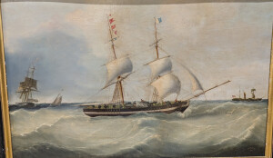 | SHORT DESCRIPTION: Painting of the Brig Jamaica headed into Liverpool by artist Joseph Heard. Painting shows the ship is in two positions. In the center image the ship is signaling for a pilot and the crew are visible on the deck taking in sail and preparing to tack to pick up the pilot. The ship is flying the Brocklebank house flag, vertical stripe of white at hoist and blue at fly, on the foremast. At the left, the ship is slowing to take on a pilot from Pilot Boat No. 8. The spanker has been scandalized and the ship is in a hove to position. The pilot signal on the main mast has been replaced with a British ensign. The Marryat flags indicate the ship is the brig Jamaica. There is a transitional steamer (paddlewheel with two masts) in the background at the right. NOTES: Sam Davidson 9/22/95: classic Joseph Heard despite added spurious atypical semicircular S. Walters signature 1846. The same added pattern of a "false" Sam Walters signature occurs in a painting of BOOMERANG at the NMM, Greenwich. JAMAICA was owned by Brocklebank- an important Whitehaven & Liverpool firm of builders and shipowners, (company livery-white hull band, and houseflag on foremast as shown.) Brig in two views. On left receiving pilot from cutter number 8. Marryat Code post 1840 1/5731=Jamaica, which accords with fleet list. Built in 1815 by Brocklebank at the Whitehaven yard, 215 tons, 84" x 24'4" x 16'4", Wrecked 1854. This is an important, vintage Joseph Heard painting. *** | CL8648 | |||||||
| 14 | 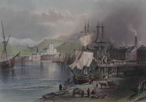 | SHORT DESCRIPTION: The image depicts the busy port town of Workington in Cumberland along the River Derwent, in the northwest of England near the Solway Firth. In the foreground of the image is a docked ship with people waiting nearby with carts. In the background is the town itself and St. Michael’s Church which sits in the middle of the town. NOTES: The image is from before page 171 of the appendix of volume 1 of “The Ports, Harbours, Watering-Places, and Coast Scenery of Great Britain," published by George Virtue in 1842. (TMMP Library DA625 .F49 Rare) The book was first published in 1838 by Charles Tilt with descriptions by William Andrew Chatto. It was then published several times in 1839 and 1842 by George Virtue, and later after 1855 by Virtue & Co. under George’s son, James S. Virtue. The name also changed slightly, but kept the "Ports, Harbours, and Watering Places" part of the title. The books that the Virtues published kept Chatto’s descriptions for the first volume, but they expanded the book to two volumes. William Beattie wrote the text for the new second volume and an appendix added to the end of the volume 1. NOTES: From the end of the 1842 edition of Volume 2: “In taking leave of these two Volumes, illustrating the Ports, Harbours, Watering-places, and Coast Scenery of Great Britain, a few words of explanation appear necessary. The work was originally commenced by Messrs. Finden [William and Edward], and for some time carried on with all the taste and spirit characteristic of these distinguished Artists. But the remuneration accruing from the sale being found inadequate to defray the expenses incurred in its production, it was offered to the present Publisher, who readily saw the improvements of which it was susceptible and became the purchaser. Arrangements were then made for its continuation. Mr. BARTLETT, whose illustrations are so familiarly and favourably known to the Public, set out on a tour of observation along the northern coasts of England and Scotland; and, after visiting every locality indicated, returned with a portfolio of drawings taken on the spot. These were immediately placed in the hands of eminent engravers; a re-issue and continuation of the work were announced; and it is gratifying to state, that the reception which it has since met with from the Public has been most liberal. With regard to the letterpress descriptions, I beg it to be expressly understood that the labours of my pen have been confined to the Second Volume and the Appendix of Vol. 1. The First Volume was written under the signature W.A.C. - prior to my connexion with the work; and, in justice to that author, I feel it at once a duty and a pleasure to conclude the work with this statement. William Beattie, M.D.” January 1842 J. Rickerby, printer, Sherbourn Lane An excerpt from of The Ports, Harbours, Watering-Places, and Picturesque Scenery of Great Britain about the print: “The town and harbour of Workington is situated on the south bank of the Derwent, near its entrance to the Irish Sea; it is about seven miles north of Whitehaven, and thirty-four south of Carlisle. It is divided into the upper and lower towns. Leland, in his venerable Itinerary, describes “Wyrkenton” as “ a lytle prety fyssher-town;” and in his day, indeed, most of the maritime stations on this coast, which have subsequently risen into importance, were nothing more than “pretty little fisher-towns.” It is also noticed by Camden as distinguished for its salmon-fishery, owing to its favourable position at the mouth of the river Derwent, whose scenery holds so distinguished a place in the poetry of the Lakes. […] the church of St. Michael, forming a prominent object in the centre of the Engraving, is a rectory in the patronage of the Curwen family, and contains a monument of Sir Patrick Curwen, Bart., who died in 1661. The chief source of industry here, as at Whitehaven and other towns of the coast, is the coal-mines, which, in the vicinity of Workington, amounts to sixteen or upwards, with a depth of from forty to ninety fathoms. The coal lies in bands or seams, divided from each other by intermediate strata. […] The quantity of coal shipped from this port, per week, amounted latterly to two thousand tons or upwards and the raising of which, with the aid of several steam-engines, afford employment to between six and seven hundred workmen. The agricultural society of Workington has contributed much to the improvement of the county, and owes its origin to the spirited and indefatigable example of the late proprietor of these mines. A staith or loading stage for collier vessels is seen on the right hand of the illustration. It is an object more valuable for its utility than for any beauty in an artistic point of view; but it is a distinguishing characteristic of all the ports engaged in the coal-trade, and, whenever it can be rendered available, reduces the expenses of the coal-owner, by obviating the necessity for keels or lighters.” NOTES: Parts of St. Michael's Church date back to approximately 1150 C.E. It has been partially destroyed twice due to fire. Workington is located in Cumberland, one of the historic counties of England. Cumberland is located in the northwestern part of England and it shares a border with Scotland. | CL16284 | |||||||
| 15 | 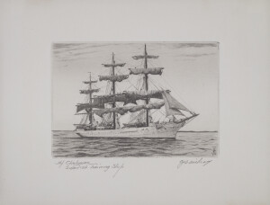 | NOTES: The ship etchings and drypoints of C.J.A. Wilson are of more than passing interest. There is charm and distinction in his work. These prints of square-riggers and other vessels are clearly by an artist who knows the sea and the ships that sail thereon--knows them in an intimate, sailorman way. And its is this fine knowledge, added to a rare artistry, that gives the pictures much of their charm and distinction. These are real "marines." The vessels sit in the water just as they should sit, and the sails are always at the right angle to the wind in relation to the vessel's course. the rigging is as correct in drawing as the hull. But it is the masterly way in which these pictures are treated in composition that first impresses one--the way in which ship, sea and sky are unified and woven into a nice harmony by means of light and shade--and line. That is really a fine achievement, and that is what tells the artistic story. Wilson seems to have naturally that sense of line in etching which expresses the mood, or the emotion of the artist so spontaneously that the work is truly autographic. And, after all, that is the primary value of either the etching or the drypoint--both are autographic. Both express the feeling of the artist while in the heat of the artistic emotion, just as a sketch in lead pencil would, with the advantage on the side of the etching, because it is more emphatic and durable. Wilson's etchings have been acquired by many leading collectors and museums in the country. NOTES: Charles J. A. Wilson was born in 1880 in Glasgow, Scotland. He came to America as an infant and in his teens moved to Newton, Massachusetts. Wilson was a prolific, self-taught, marine artist who gained much of his experience from working in the Boston shipyards. He worked as an artist for Bethlehem Shipbuilding in East Boston, etching their ships from blueprints. During the World War I, Wilson spent two years in France. After the war he was commissioned to paint and etch American ships and marine views. During World War II, Wilson worked in Boston as an official Coast Guard artist. He was a member of the Boston Society of Printmakers, and exhibited with Pennsylvania Academy of the Fine Arts, Society of American Etchers and the Currier Gallery. VESSEL INFORMATION- VESSEL NAME: AF CHAPMAN Alternate vessel names: (1) DUNBOYNE (1888-1915); (2) 1915-1923); (3) AF CHAPMAN (1923-PRESENT) VESSEL TYPE: SWEDISH NAVAL TRAINING SHIP VESSEL DATES: 1888 SHIPBUILDER: SHIPBUILDING CO. SHIPBUILDER LOCATION: ENGLAND, WHITEHAVEN | CL15993 | |||||||
| 16 | No image URL. | Ellis Island Immigration Station (N.Y. and N.J.)–History–Pictorial works. | New York Harbor (N.Y. and N.J.)–History–20th century–Pictorial works. | Charles R. Patterson Photographs | MS0255 | |||||
| 17 | 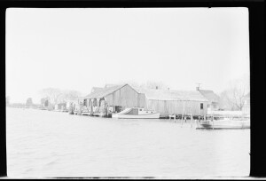 | 4/1952 | Wicomico County (Md.).; Wicomico River (Wicomico County and Somerset County, Md.). | Envelope: "Whitehaven. April 1952" | Dwellings–Maryland–Wicomico County.; Harbors–Maryland–Wicomico County.; Motorboats–Maryland–Wicomico County. | Shows a view looking across the water towards some homes and a covered wharf. A motorboat is moored at the wharf. There is no caption for this negative. | MS0063/01-697#0697-B | |||
| 18 | 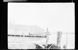 | 4/1952 | Wicomico County (Md.).; Wicomico River (Wicomico County and Somerset County, Md.). | Envelope: "Whitehaven. April 1952" | Dwellings–Maryland–Wicomico County.; Harbors–Maryland–Wicomico County. | Shows a view looking across the water towards some homes and a covered wharf. This is the opposite end of the wharf as shown in 0697-B. There is no caption for this negative. | MS0063/01-697#0697-C | |||
| 19 | NOTES: [L. Forbes, 10/25/2021] This is definitely Maryport looking at the lighthouse and landscape in background (house with three chimneys--Maryport Castle), and the headland with three hills. I agree it's not by Samuel Walters or Robert Salmon but it is Liverpool school. See LE 1403 which shows the lighthouse sitting on the mole, which has the same distinct shape as the lighthouse on this painting. [Stephen M. Riley, National Maritime Museum, Greenwich, England, May 10, 1977] This is not Liverpool, and not by Walters. He suggests that this may be either Whitehaven or Maryport in the background. It appears that the name on the vessel may be Nancy of Maryport. It is possible that the artist may be Henry Collins. In 1998 Julia Korner said this was by the circle of Robert Salmon The ship is shown in three positions. [David Dick, 11/16/1998] The vessel has the lines of a snow. However, it varies somewhat from a brig. Lloyd's only lists a brig with the name NANCY out of MARYPORT (to America) volumes 1818-1819 and 1824-25. No record in 1829-1830. Reference Flags at Sea indicates clearly that the name of the vessel during this period could be on the house flag. This is certainly the case with QO 1167. | CL12817 | ||||||||
| 20 | 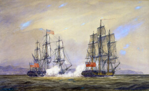 | NOTES: Excerpts from 'A Naval History of the American Revolution' by Gardner Weld Allen, pages 337-350: Captain John Paul Jones sailed USS Ranger to France in December 1777. For the first two months after his arrival Jones spent much time in Parils conferring with the American Commissioners. Jones had been promissed command of the 74-gun Indien, then building at Amsterdam, but when political reasons caused this vessel to be transferred to France it was suggested that Jones take USS Ranger on a cruise to attack defenseless seaports in England and against the commerce of England in its own waters. In February Jones orchestrated having his ship and the new American national flag saluted by the French fleet in Quiberon Bay. From Quiberon Bay the Ranger proceeded to Brest and arrived there on March 8th. Jones stayed in this vicinity for about a month and on April 10th Jones sailed to cruise on British waters.On the 14th between Scilly and Cape Clear, a brigatine was taken and sunk. On the 17th, off Dublin, a ship was captured and sent back to Brest. Ranger stood towards the Isle of Man intending to make an attack on Whitehaven, but the weather deteriorated so the attack was postponed. During the next few days a revenue cutter was chased and a schooner and sloop were sunk. On April 21st, off Carrickfergus, Jones detained a fishing boat and learned a large ship at anchor in the road was the 20-gun HMS Drake. Jones determined to attack her that night but the weather made anchoring difficult and the attack was postponed. On April 22nd the weather moderated and Jones resolved once more to attack Whitehaven and set fire to the shipping in the port (see page 344-347 for a full account of Jones's activities). On the morning of April 24, 1778, Ranger was again at Carrickfergus and would have entered the port had he not seen HMS Drake preparing to come out. Drake's boat was sent out of the port to reconnoitre Ranger. Jones kept Ranger's stern towards the small boat and allowed the British officers to come on board at which point he was surprised to find himself a prisoner. HMS Drake worked slowly out of the port. At length Drake weathered the point and, having led her out to about mid-channel, Jones stated "I suffered her to come within hail. The Drake hoisted English colors and at the same instant the American stars were displayed on board the Ranger. I expected that preface had been now at an end, but the enemy soon after hailed, demanding what ship it was? I directed the master to answer, the American Continental ship Ranger, that we waited for them and desired that they would come on; the sun was now little more than an hour from setting, it was therefore time to begin.’ The Drake being astern of the Ranger, I ordered the helm up and gave her the first broadside. The action was warm, close, and obstinate. It lasted an hour and four minutes, when the enemy called for quarters, her fore and main-topsail yards being both cut away and down on the cap, the top-gallant yard and mizengaff both hanging up and down along the mast, the second ensign which they had hoisted shot away and hanging on the quarter-gallery in the water, the jib shot away and hanging in the water, her sails and rigging entirely cut to pieces, her masts and yards all wounded, and her hull also very much galled. I lost only Lieutenant Wallingsford and one seaman, John Dougall, killed, and six wounded, among whom are the gunner, Mr. Falls, and Mr. Powers, a midshipman, who lost his arm. One of the wounded, Nathaniel Wills, is since dead ; the rest will recover.” Jones estimated the British loss at forty-two killed and wounded, but it was probably less; the captain was killed and the lieutenant mortally wounded. The day after the battle both ships were employed in repairing injuries. When ready to sail, the Ranger and Drake passed out to sea by the North Channel, owing to a shift of the wind, and returned to Brest by way of the west coast of Ireland. Both vessels arrived safely at Brest May 8. NOTES: Information concerning the Bailey Collection of watercolor views of U.S. Naval actions (1745-1850) in The Mariners’ Museum, Newport News, Virginia. In 1940 The Mariners’ purchased from a dealer in London a collection of 254 watercolor drawings, which were at the time attributed to Charles T. Warren (1767-1823), an engraver. They were Represented as having belonged to a Charles Kingsley Bailey, and have henceforth been referred to as the Bailey Collection. The views in the collection range from the Siege of Louisburg in 1745 to an action which occurred in 1850. Simply on the basis of the breadth of coverage, then, it appeared unlikely that these were executed contemporary to the action by one person. Moreover, persons making studies of individual vessels represented in the collection have pointed out that there are major inaccuracies in the details of the vessels. Research initiated by the museum from 1974 to 1982 subsequently revealed that the watercolors were actually done by Irwin John Bevan (1852-1940). Welsh-born Bevan was a keen naval historian and his sketches and paintings included many maritime subjects. His work can be seen in Sea Fights of the Great War by W.L. Wyllie and M. F. Wrenn, published in 1918. Since Bevan did book illustrations, the present assumption is that this group of watercolors was executed to illustrate a projected work on the history of the U.S. Navy, especially as it related to the British Navy. Detailed contemporary accounts of the U.S.-British actions were written down in letters, official reports and newspapers of the day and nineteenth century historians had these sources available for their texts. The accounts accompanying Bevan’s paintings relied heavily on all these sources. Notwithstanding this however, the paintings must not be taken as primary documents of either the vessels or the engagements. They should be viewed in the context of the artist’s conceptions, which may vary considerably in their reliability. It is left to the discretion of the researcher whether or not this material will be of value in the current project. | CL137 | |||||||
| 21 | 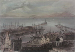 | SHORT DESCRIPTION: The image shows the town of Maryport, England, with the Irish Sea and hills in the distance. On the sea there are several sailing ships, as well as a steamship with smoke coming from the funnel. The port is filled with various types of sailing ships, and there is another steamship with a single funnel. In the foreground there is a group of people near the water, there are many buildings, and at the top of a set of stairs that overlook the town there are two men in hats. There are two piers that extend into the water, one with a lighthouse at the end. NOTES: The image is from before page 53 of volume 2 of “The Ports, Harbours, Watering-Places, and Coast Scenery of Great Britain," published by George Virtue in 1842. (TMMP Library DA625 .F49 Rare) The book was first published in 1838 by Charles Tilt with descriptions by William Andrew Chatto. It was then published several times in 1839 and 1842 by George Virtue, and later after 1855 by Virtue & Co. under George’s son, James S. Virtue. The name also changed slightly, but kept the "Ports, Harbours, and Watering Places" part of the title. The books that the Virtues published kept Chatto’s descriptions for the first volume, but they expanded the book to two volumes. William Beattie wrote the text for the new second volume and an appendix added to the end of the volume 1. NOTES: From the end of the 1842 edition of Volume 2: “In taking leave of these two Volumes, illustrating the Ports, Harbours, Watering-places, and Coast Scenery of Great Britain, a few words of explanation appear necessary. The work was originally commenced by Messrs. Finden [William and Edward], and for some time carried on with all the taste and spirit characteristic of these distinguished Artists. But the remuneration accruing from the sale being found inadequate to defray the expenses incurred in its production, it was offered to the present Publisher, who readily saw the improvements of which it was susceptible and became the purchaser. Arrangements were then made for its continuation. Mr. BARTLETT, whose illustrations are so familiarly and favourably known to the Public, set out on a tour of observation along the northern coasts of England and Scotland; and, after visiting every locality indicated, returned with a portfolio of drawings taken on the spot. These were immediately placed in the hands of eminent engravers; a re-issue and continuation of the work were announced; and it is gratifying to state, that the reception which it has since met with from the Public has been most liberal. With regard to the letterpress descriptions, I beg it to be expressly understood that the labours of my pen have been confined to the Second Volume and the Appendix of Vol. 1. The First Volume was written under the signature W.A.C. - prior to my connexion with the work; and, in justice to that author, I feel it at once a duty and a pleasure to conclude the work with this statement. William Beattie, M.D.” January 1842 J. Rickerby, printer, Sherbourn Lane NOTES: The current Maryport lighthouse is considered the oldest cast iron lighthouse in the world and was built in 1846. However, there has been a lighthouse at the end of a pier in Maryport since 1796, and that is the structure that is visible in this print. An excerpt from The Ports, Harbours, Watering-Places, and Picturesque Scenery of Great Britain about the print. “Maryport derives its name from that of a patriotic lady in the neighbourhood, the wife of Mr. Humphrey Senhouse, of Netherhall, who, in 1750, took a lively interest in the place, and, with the assistance of her family connection and the spirited inhabitants of the place, succeeded in raising it to the distinction of a port town; a title to which it has added many additional claims within the last ten years. […] The commerce of Maryport, according to the last report, is decidedly on the increase; and the many advantages it possesses for ship-building and refitting are more and more appreciated by all trading-vessels frequenting this coast. The exports consist principally of coal for Scotland and Ireland, which is furnished in great abundance by collieries in this district, and affords the means of comfortable subsistence to a hardy race of seamen, who, in the hour of danger, have often “done the state some service”. The importations consist of timber, flax, and iron, from the Baltic, and various articles of domestic utility from the opposite coasts. The herring-fishery has hitherto been prosecuted with great success; upwards of twenty boats were lately engaged in this enterprise. In winter, the boat-crews are employed in the taking of cod-fish, which is here caught in great abundance, and finds a ready sale on the market-days of Tuesday and Friday. The river Ellen, or Elne, affords no inconsiderable supply of salmon-trout during the season; and as the daily steam-vessels running between Carlisle, the Scottish Coast, and Liverpool, generally tough at Maryport for the convenience of passengers, there is a constant air of bustle and activity about the per that renders the place very agreeable as a sojourn in the summer months. The view across the Firth is one of the finest on the coast and the inland scenery is proverbially beautiful. It is only six miles from Cockermouth; and is further enlivened by the continual traffic along the great coast-road which connects it with Carlisle on the east, and with Workington and Whitehaven on the west. ADDITIONAL INFORMATION: Maryport developed a shipyard in the 19th century. | CL16278 |
Created 2026 by Don Barker, CBMM volunteer, for the Chesapeake Shipbuilding Project. shipbuilding@sailingworkboats.es